/prod01/prodbucket01/media/durham-university/departments-/geography/Matt_Couchmann-3872X1296.JPG)
Geography Available Research Project
Is coastal rock-slope failure unpredictable?
In comparison to the rapidly eroding soft rock cliffs of the UK, the erosion of hard-rock cliffed coastlines is often assumed to be episodic and to some degree random and unpredictable (Benjamin et al., 2020). As a result, a tension emerges between the delineation of long-term averaged erosion rates via coastal risk management policy, data on cliff face erosion that is increasingly collected as part of coastal monitoring programmes, and the direct experience of people who witness coastal erosion on a day-to-day basis (Rosser et al., 2013). A key challenge has been in reconciling the need for high-resolution data at high frequencies over a sufficiently long period to capture emergent patterns of rock cliff erosion from which accurate erosion rates and future patterns can be distilled. It is only with this type of erosion data that links to key controls such as underlying rock mass structure, the weather or nearshore hydrodynamics can be made, and explorations of future erosion pathways considered.
This project will explore a dataset that uniquely provides a window into long-term rock cliff erosion patterns at high temporal and spatial frequencies. Based upon more than a decade on repeat 3D laser scanning across an actively eroding section of coastal rock slope, the data captures >105 rockfalls with sizes ranging from that of a coffee cup to a tipper truck (Williams et al., 2018). The project will seek to use this dataset to consider the degree to which rockfalls exhibits patterns both in space and time, how they link to the underlying rock mass structure, and from this consider the degree to which the location of future rockfall can be predicted based upon the behaviour that is identified. The student will develop skills in field data collection (3D laser scanning and geomatics), geospatial analysis of 3D data, and machine learning. This results will likely hold significant implications for risks to coastal infrastructure, the design of future monitoring campaigns and the future management and prediction of coastal erosion risk.
Lead supervisor(s) and email addresses
Professor Nick Rosser (n.j.rosser@durham.ac.uk)
Professor Matt Brain (matthew.brain@durham.ac.uk)
Key references
Benjamin, J., Rosser, N., & Brain, M. (2020). Emergent characteristics of rockfall inventories captured at a regional scale. Earth Surface Processes and Landforms, 45(12), 2773-2787. https://doi.org/10.1002/esp.4929
Rosser, N. J., Brain, M. .., Petley, D. N., Lim, M., & Norman, E. C. (2013). Coastline retreat via progressive failure of rocky coastal cliffs. Geology, 41(8), 939-942. https://doi.org/10.1130/g34371.1
Williams, J., Rosser, N., Hardy, R., Brain, M., & Afana, A. (2018). Optimising 4-D surface change detection: an approach for capturing rockfall magnitude–frequency. Earth Surface Dynamics, 6(1), 101-119. https://doi.org/10.5194/esurf-6-101-2018
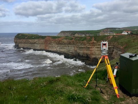
Terrestial laser scanning of coastal rock slopes, North Yorkshire, UK. Photo credit: N. Rosser.